Sabre52
Cave Dweller  Me and my gal, Rosie
Member since August 2005
Posts: 20,456
|
Post by Sabre52 on Jul 28, 2017 18:05:21 GMT -5
Nice color change in that stuff! I see the same thing in our local flint that is found where Amerinds heat treated it. Usually more golds for us but sometimes some nice reds too....Mel
|
|
jamesp
Cave Dweller
Member since October 2012
Posts: 36,155
|
Post by jamesp on Jul 29, 2017 5:09:53 GMT -5
Nice color change in that stuff! I see the same thing in our local flint that is found where Amerinds heat treated it. Usually more golds for us but sometimes some nice reds too....Mel This Savannah River site has massive boulder exposure at the forest floor in this large zone. Consider that a mature forest takes 100 years to mature and the fact they burn regularly. In 10,000 years many a hot fire occurred there, this is the driest section of Georgia. If you sledge a 20 to 50 pound chunk of one of the chert boulders water pours out of the cavities and the face is soaking wet in general. It is such a wet chert it is explosive when tossed in a campfire due to the water content. In a fire it splits 2-4-8-16-256-512 or some exponential rate. Truly making whistling sounds as fragments fly at an increasing rate. Just shedding light on cyclic forest fires over a recent time period(just pick 5000 to 10,000 years) and the effect on this mineral rich chert. Many of the soil roads were paved for the express reason of keeping rock hunters from collecting on them. The soil roads were cut and continually graded right at the sweet spot for surface heat treated chert. A perfect storm. Site is just below Augusta. Dry there. But plowed heavily for field crops on massive scale. For 3 counties the Savannah River site is one of the only high and dry spots on the bank of the Savannah River. Making it a densely populated in Native man. Archeologists marveled at the massive chert mining operations the Natives left behind.  |
|
Sabre52
Cave Dweller
Me and my gal, Rosie
Member since August 2005
Posts: 20,456
|
Post by Sabre52 on Jul 29, 2017 14:11:20 GMT -5
James, the Amerind flint ( chert) quarry we have on our hill here on the ranch was cleared and burned in 2009. The flint exploded exactly like you've said. Shards have all those odd conical depressions in them from the heat and explosion. I've often wondered, if I was to dig beneath the old fire pits and get far enough from the heat source ,if I'd find a trove of properly heat treated flint nodules. Be cool to find some nice red ones...Mel
|
|
Tommy
Administrator 
Member since January 2013
Posts: 12,652
|
Post by Tommy on Jul 31, 2017 14:40:53 GMT -5
|
|
Sabre52
Cave Dweller
Me and my gal, Rosie
Member since August 2005
Posts: 20,456
|
Post by Sabre52 on Jul 31, 2017 16:24:11 GMT -5
Man, that burn was bad! Looks like Flyaway Gulch burnt out there at Bagby. Good time to hunt for jade too....Mel
|
|
|
|
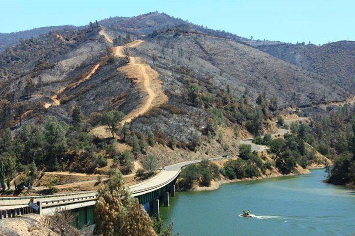
Post by aDave on Jul 31, 2017 18:20:32 GMT -5
Tommy , I've picked up rocks from that cut just north of the bridge in the first pic. Would have swore it was serpentine. Are both varieties there? Dave ETA: 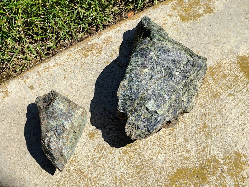
|
|
Tommy
Administrator
Member since January 2013
Posts: 12,652
|
Post by Tommy on Jul 31, 2017 19:17:55 GMT -5
Tommy , I've picked up rocks from that cut just north of the bridge in the first pic. Would have swore it was serpentine. Are both varieties there? Dave Good question Dave - I actually have no idea. Someone commented on Facebook that you could see Mariposa outcrop in the one of the photos and I made assumptions ... because its green  I've never been there myself I don't know where it's collected. |
|
Sabre52
Cave Dweller
Me and my gal, Rosie
Member since August 2005
Posts: 20,456
|
Post by Sabre52 on Jul 31, 2017 19:45:53 GMT -5
I've only hunted mariposite on the south side of the Merced River Gorge. About halfway down the gorge there is an active spring and mine tunnel and there is good mariposite there. The Pinetree and Josephine mine, just north of Bear Valley on the left heading north, if you can get in, has really nice gemmy Mariposite. Was posted last time I looked. Used to hunt north of the Merced R. with my pop but I can't remember where the site was. Most the green you see is serpentine but there are a lot of nephrite jade prospects north of the Merced Gorge too and the jade is pretty nice stuff. So homogeneous it will actually tumble. Most has a hint of gray in the green but I've seen some that was really nice....Mel
|
|
|
|
Post by aDave on Jul 31, 2017 19:49:34 GMT -5
Tommy , I've picked up rocks from that cut just north of the bridge in the first pic. Would have swore it was serpentine. Are both varieties there? Dave Good question Dave. I have no idea. Someone commented that you could see Mariposa outcrop in the one of the photos and I made assumptions ... because its green I've never been there myself I don't know where it's collected. FWIW, I asked Sabre52 about that cut, and he indicated he has collected serpentine from that spot. I was there years ago, and we saw it as we descended toward the bridge going northbound. We pulled over, grabbed a couple of rocks, and then took off. This was during a Hwy 49 trip that we started in Oakhurst and moved north to Grass Valley. We were on our way to do a flyfishing trip in Redding and visiting friends. I've always loved the Sierra foothills, and we were not disappointed. Were those your pics from the weekend? How did it go, and how "black" did you get? NVM...I just noticed you said those were Facebook photos. ETA: I see Mel jumped in as I was typing. Thanks for the clarification, Sabre52 . Dave |
|
Tommy
Administrator
Member since January 2013
Posts: 12,652
|
Post by Tommy on Jul 31, 2017 20:34:19 GMT -5
The other part of my assumption was based on when the local clubs arrange field trips to collect Mariposite they always refer to it as the Mariposite road-cut on hwy 49. It's quite well known locally although as I said I've never gone looking for it.
We drove 49 north last year across the bridge and up to Coulterville and I had my eye out for the road cut everyone talks about but did not see anything.
|
|
|
|
Post by aDave on Jul 31, 2017 20:40:10 GMT -5
The other part of my assumption was based on when the local clubs arrange field trips to collect Mariposite they always refer to it as the Mariposite road-cut on hwy 49. It's quite well known locally although as I said I've never gone looking for it. We drove 49 north last year across the bridge and up to Coulterville and I had my eye out for the road cut everyone talks about but did not see anything. I just sent you a PM. Wasn't trying to upstage you at all. I had serious questions. If It seemed like it was so, I apologize. Dave |
|
Tommy
Administrator
Member since January 2013
Posts: 12,652
|
Post by Tommy on Jul 31, 2017 20:45:26 GMT -5
Haha not at ALL in the slightest Dave! No worries my friend. I'm glad you fact checked it. I'm wildly curious about where the road cut it so when I saw that green patch north of the bridge ... well that just had to be it |
|
Tommy
Administrator
Member since January 2013
Posts: 12,652
|
Post by Tommy on Aug 1, 2017 10:09:08 GMT -5
Sabre52 they released the "operational map" yesterday and it has new information that has not been shown on any previous map. From searching Google maps with your instructions about the turnoff to the monolith I've marked the GPS location with the red arrow on the new map and it appears that the monolith and collecting area is squarely inside the burn zone. The double x's indicate where they have bulldozed. 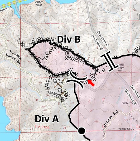 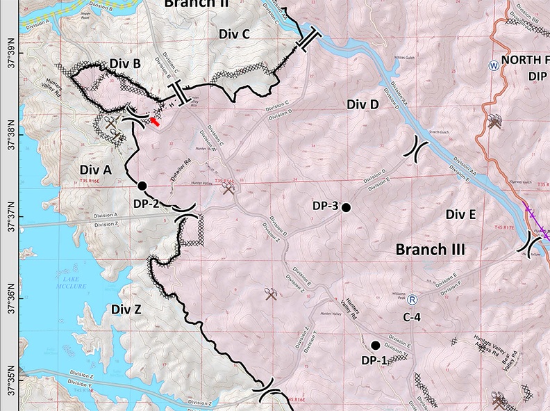 Edit to add: It also appears that your old ranch did indeed burn but you probably already knew this 
|
|
Sabre52
Cave Dweller
Me and my gal, Rosie
Member since August 2005
Posts: 20,456
|
Post by Sabre52 on Aug 1, 2017 15:58:55 GMT -5
Tommy, I brought up the Google aerial photo and compared it to your map and it's very close. I think the jasper monolith is where you can see some white mine dumps if you blow the photo up and it may be in the burn area all right. If you look at a really close up of the aerial photo you can see the green canyon just west of the monolith that has a rectangular water tank in it. Tom's dog swam in that tank a bit and then we hike roughly east of that green canyon to the monolith and that looks to be where the white tailings are. We did not see them as we climbed the west side of the outcrop. It had big trees on some of it so I think it's partly obscured in the photo but if it burned over, it should be very visible and poison oak free too....Mel
|
|
Tommy
Administrator
Member since January 2013
Posts: 12,652
|
Post by Tommy on Aug 5, 2017 9:48:53 GMT -5
wasn't me... 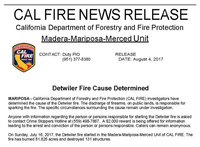 |
|
Sabre52
Cave Dweller
Me and my gal, Rosie
Member since August 2005
Posts: 20,456
|
Post by Sabre52 on Aug 5, 2017 10:47:05 GMT -5
Cause of fire totally makes sense as there is a meadow just before the creek crossing on the road to the poppy sites where some folks have set up an impromptu shooting range. I've seen them shooting there many times before when I was going in to hunt poppy. Really stupid to shoot there when the grass is dry and the ground covered with quartz minerals that readily spark on impact. First time I've heard of a fire caused that way though. It's usually Illegal burning, a jerkoff welding in the tall grass or someone dragging a pull behind mower. Usually had a good fire every couple of years up there in Hunters Valley.....Mel
|
|
Deleted
Deleted Member
Member since January 1970
Posts: 0
|
Post by Deleted on Aug 6, 2017 18:26:30 GMT -5
Cause of fire totally makes sense as there is a meadow just before the creek crossing on the road to the poppy sites where some folks have set up an impromptu shooting range. I've seen them shooting there many times before when I was going in to hunt poppy. Really stupid to shoot there when the grass is dry and the ground covered with quartz minerals that readily spark on impact. First time I've heard of a fire caused that way though. It's usually Illegal burning, a jerkoff welding in the tall grass or someone dragging a pull behind mower. Usually had a good fire every couple of years up there in Hunters Valley.....Mel Usually, it's straight up arson. Notice the fires always start on the side of a road? They even busted a dude out here about 10 years ago. Admitted responsibility for over 20 fires. aDave |
|
Sabre52
Cave Dweller
Me and my gal, Rosie
Member since August 2005
Posts: 20,456
|
Post by Sabre52 on Aug 6, 2017 18:49:20 GMT -5
Yeah, I've heard it's not uncommon to have a part time fireman start fires to get work. We definitely had a firebug working the area for a few of the years we had our place up there. Think they finally caught him though...Mel
|
|
|
|
Post by aDave on Aug 6, 2017 20:14:12 GMT -5
Usually, it's straight up arson. Notice the fires always start on the side of a road? They even busted a dude out here about 10 years ago. Admitted responsibility for over 20 fires. aDave Yeah, I've heard it's not uncommon to have a part time fireman start fires to get work. We definitely had a firebug working the area for a few of the years we had our place up there. Think they finally caught him though...Mel Roadside fires are often found to be not criminal. I hated roadside fires. Biggest problem was exhaust/carbon issues from vehicles as well as failing catalytic converters. Most often, using the scientific method, roadside fires were found to be "undermined," due to the inability to rule out all accidental sources. Unless there are witnesses who can place folks along the roadside, it's an uphill challenge to determine arson. Mel, as far as your "part time fireman" scenario, they do exist, but those scenarios are not too common. Dave |
|
Tommy
Administrator
Member since January 2013
Posts: 12,652
|
Post by Tommy on Aug 6, 2017 20:20:26 GMT -5
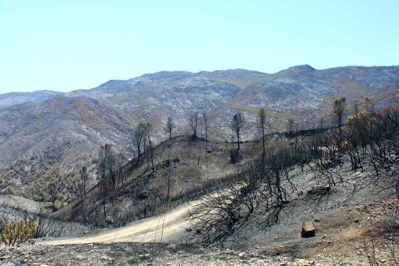
So we went up there yesterday - hope nobody minds if I share a few photos here instead of starting a new report. We started off feeling guilty like we were barging into the scene of a disaster - and we were - but all down Hunters Valley rd. we saw nothing but house after house that had been saved - no doubt by heroic efforts of the fire fighters and the home owners alike. Two houses up on a hill in particular should have burned - the whole valley around them was black but yet the houses were still there. Serious hero stuff went on here. Once we got off the road and climbing to the ridge we never saw another soul or vehicle all day. On to some photos... yes we took the dog. I had said earlier we wouldn't but I'm glad we did - he loves this stuff. On our way down Hunters Valley we had to stop and ask for directions once... the response was just a point in the direction of the fire.  Once we neared the ridge the whole place was a mess of bull dozer lines - this wide swath in particular just had to be walked and we did - all the way up to the ridge and over - but didn't find anything resembling jasper. Lots of white quartz newly exposed though. 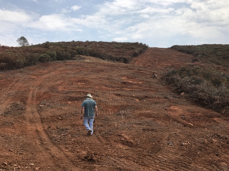 Looking for rocks was next to impossible - but it wasn't for lack of trying. I must have windowed a thousand green rocks in the course of the day. We're glad we went but the situation will definitely improve after a hard rain or two. Everything that wasn't blackened was pink from the air drops... 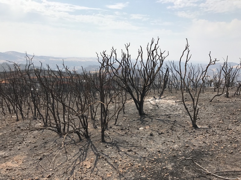 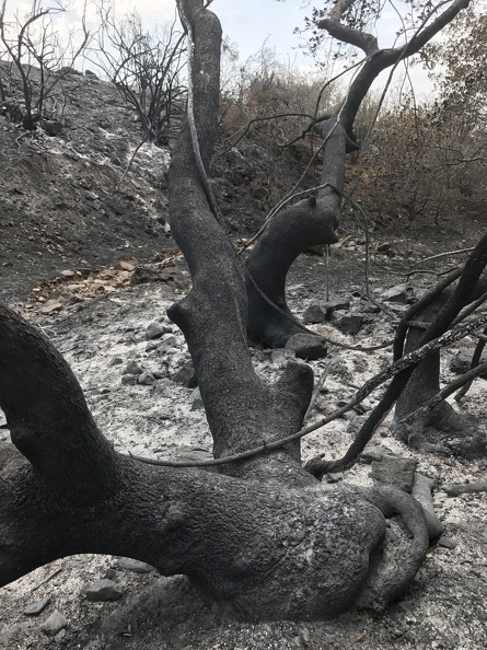 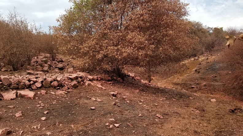 This guy didn't make it... 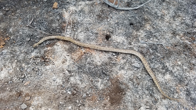 Neither did the claim area - it was completely burnt on both sides of the road. I could tell that someone had hastily tried to get the signs back up but didn't try very hard at it. Still we didn't go into the claim. 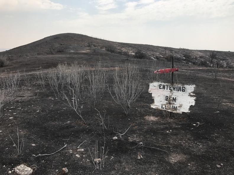 In one of the rocky ravines down from the ridge I did find one piece of jasper - it's pretty porous and low quality but I also saw some digging pits right in the same area so it's worth exploring again. 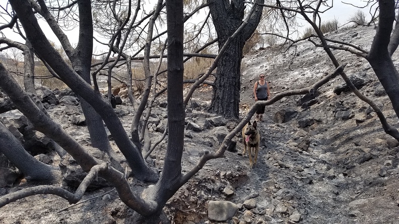 We finished the day with a nice clean up and foot dip on the ice cold Lake McSwain. Charley is a water dog to the core - he never got tired of swimming out for the ball - but he also slept like a baby on the way home. 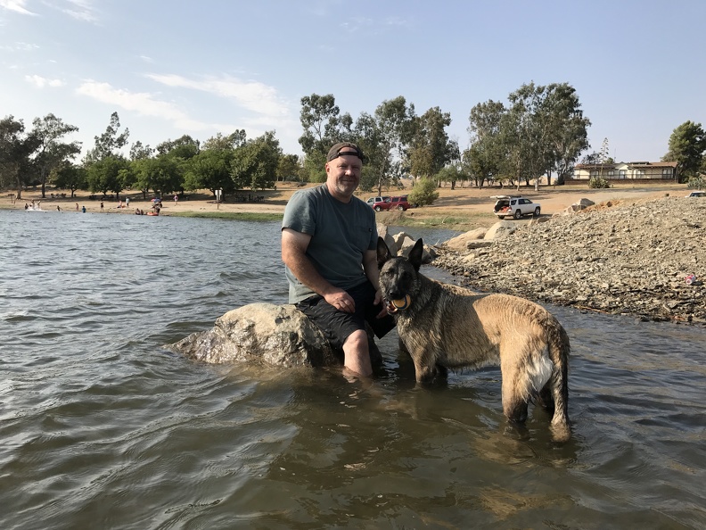 |
|


 I've never been there myself I don't know where it's collected.


