jamesp
Cave Dweller 
Member since October 2012
Posts: 36,471
|
Post by jamesp on Apr 10, 2022 1:34:20 GMT -5
This theoretical impact video compares the smaller Carolina Bays up in New Jersey receiving an average energy of .88 MT of tnt/square kilometer verses the Carolina Bays down in South Carolina which received an average energy of 7.95 MT of tnt/square kilometer.
|
|
jamesp
Cave Dweller
Member since October 2012
Posts: 36,471
|
Post by jamesp on Apr 10, 2022 1:49:47 GMT -5
Carolina Bays found in 2001 in soft soils in Nebraska with similar elliptical orientations oriented toward the laurentide ice impact ?
|
|
|
|
Post by vegasjames on Apr 10, 2022 2:06:59 GMT -5
This theoretical video describes the first 60 minutes of a 1.6 mile diameter asteroid hitting the 2 mile deep laurentide ice formation. Many strange events occur to the water and ice ejecta as it rises high above the earth and returns back to earth. Other unexpected events are described. One thing I really dislike about this video is he starts out as this is how it happened. No, there is no proof that this is how it happened. He should have rephrased that as this is how I think it may have happened instead of presenting his hypothesis as fact.
Anyway, one part of his video does go with a point I already brought up. As he said, the ice would have come down with the equivalent of a 3 megaton nuclear device. That much energy striking the Earth would not produce impressions less than 10 feet deep. Furthermore, it is known that a nuclear device like this and even an earthquake can lead to to the formation of shocked quartz, a major indicator of impact events. So where is the shocked quartz if this was truly an impact event? So far, I have seen zero evidence for this.
And he mentioned the shock wave and showed a pic of the Tunguska event that he also presents as fact as being from a comet when this has never been proven. There are different hypotheses on what actually led to the Tunguska event. Anyway, the point here is a lot of that land would have been covered by forest. And the shockwave would have laid these forests flat. I would think that some of this wood would have been petrified. In fact, petrified wood has been found in Michigan for one. If this was an impact event the shock wave again would have laid down these forests directionally. Is there any evidence showing directional laying down of petrified forests around the suspected impact areas?
|
|
jamesp
Cave Dweller
Member since October 2012
Posts: 36,471
|
Post by jamesp on Apr 10, 2022 2:19:46 GMT -5
This video utilizes high level radar images to illustrate the bays in detail along with a mass extinction event at 12,900 years ago that correlates with the theoretical temperature changes at that time. The impressions of the bays due to soft soils at geographical zones is also mentioned.
Information is dialed down for average layman to comprehend.
At 2:50 of video he points out that the long dimension of the ellipses rotates toward the suggested impact site as moving from south in Georgia to north in New Jersey. This orientation is highly suggestive that the bays were caused by a single source impact.
|
|
jamesp
Cave Dweller
Member since October 2012
Posts: 36,471
|
Post by jamesp on Apr 10, 2022 2:36:53 GMT -5
This theoretical video describes the first 60 minutes of a 1.6 mile diameter asteroid hitting the 2 mile deep laurentide ice formation. Many strange events occur to the water and ice ejecta as it rises high above the earth and returns back to earth. Other unexpected events are described. One thing I really dislike about this video is he starts out as this is how it happened. No, there is no proof that this is how it happened. He should have rephrased that as this is how I think it may have happened instead of presenting his hypothesis as fact. Anyway, one part of his video does go with a point I already brought up. As he said, the ice would have come down with the equivalent of a 3 megaton nuclear device. That much energy striking the Earth would not produce impressions less than 10 feet deep. Furthermore, it is known that a nuclear device like this and even an earthquake can lead to to the formation of shocked quartz, a major indicator of impact events. So where is the shocked quartz if this was truly an impact event? So far, I have seen zero evidence for this. And he mentioned the shock wave and showed a pic of the Tunguska event that he also presents as fact as being from a comet when this has never been proven. There are different hypotheses on what actually led to the Tunguska event. Anyway, the point here is a lot of that land would have been covered by forest. And the shockwave would have laid these forests flat. I would think that some of this wood would have been petrified. In fact, petrified wood has been found in Michigan for one. If this was an impact event the shock wave again would have laid down these forests directionally. Is there any evidence showing directional laying down of petrified forests around the suspected impact areas?
I'm not sure what to say to you James. Let's just say the bays are mysterious. Maybe impacts made by ice or mud don't behave like a rock impacts and how is an impact site dated if water/ice made the impact ? I will say that each new video I watch proves these to be an impact event. And one that rewrites modern theory about the ice age extinction. They only found the bays in Nebraska 20 years ago. This is a fairly recent discovery with unique circumstances. The subject has not been accepted by many mainstream scientists but it is hard to explain away their great numbers and impact like orientations. To me it appears to be the best evidence we have of a recent catastrophic event in North America. |
|
jamesp
Cave Dweller
Member since October 2012
Posts: 36,471
|
Post by jamesp on Apr 10, 2022 2:50:19 GMT -5
Question. During the ice ages did permafrost ever form in the area in question? I've seen some odd permafrost patterns that sometimes are quite homogenous over a large area. I can conceive that the consistent oval shapes could be explained by subsequent drifting dune action by prevailing winds at certain times. Drifting sand dunes in permafrost areas are a common phenomenon in the arctic today. You may have the answer there Randy. The more videos I open seems to lead me to think these are impacts. Effects of wind also makes good sense. Maybe the scientists will provide answers soon. One of the videos reviewed the 90 years these things have been studied. A long time and still no concrete answers. That is just odd because these depressions sure seem to be a recent event with basic structure with so many samples to study. |
|
|
|
Post by vegasjames on Apr 10, 2022 2:56:07 GMT -5
One thing I really dislike about this video is he starts out as this is how it happened. No, there is no proof that this is how it happened. He should have rephrased that as this is how I think it may have happened instead of presenting his hypothesis as fact. Anyway, one part of his video does go with a point I already brought up. As he said, the ice would have come down with the equivalent of a 3 megaton nuclear device. That much energy striking the Earth would not produce impressions less than 10 feet deep. Furthermore, it is known that a nuclear device like this and even an earthquake can lead to to the formation of shocked quartz, a major indicator of impact events. So where is the shocked quartz if this was truly an impact event? So far, I have seen zero evidence for this. And he mentioned the shock wave and showed a pic of the Tunguska event that he also presents as fact as being from a comet when this has never been proven. There are different hypotheses on what actually led to the Tunguska event. Anyway, the point here is a lot of that land would have been covered by forest. And the shockwave would have laid these forests flat. I would think that some of this wood would have been petrified. In fact, petrified wood has been found in Michigan for one. If this was an impact event the shock wave again would have laid down these forests directionally. Is there any evidence showing directional laying down of petrified forests around the suspected impact areas?
I'm not sure what to say to you James. Let's just say the bays are mysterious. Maybe impacts made by ice or mud don't behave like a rock impacts and how is an impact site dated if water/ice made the impact ? I will say that each new video I watch proves these to be an impact event. And one that rewrites modern theory about the ice age extinction. They only found the bays in Nebraska 20 years ago. This is a fairly recent discovery with unique circumstances. The subject has not been accepted by many mainstream scientists but it is hard to explain away their great numbers and impact like orientations. To me it appears to be the best evidence we have of a recent catastrophic event in North America. I have already posted several possibilities as to how these orientations could have occurred.
And I thought of yet another one that actually makes a lot more sense than an impact event that would would have created evidence in the rocks, would have created larger and deeper depressions, etc.
The other possibility is a volcano. There are extinct volcanoes in Eastern Canada and the Eastern United States. To be considered extinct, they only have to be inactive 10,000 years, which is less that the dated age of many of the bays. A directional blast from a collapsing side wall like that happened with Mt St. Helens under an ice cap would have sent ice flying without the changes in rock structure seen with impact events. The falling ice or rock would also have less impact energy than a strike by a meteorite or comet impact.
Furthermore, the weak wall of a volcano could collapse more than once creating more than one event in the same direction, which again would be virtually impossible with the impact hypothesis.
So, there are various possibilities, and still no real solid evidence of an impact event such as geological changes such as shattercones or shocked quartz consistent with impact events.
|
|
jamesp
Cave Dweller
Member since October 2012
Posts: 36,471
|
Post by jamesp on Apr 10, 2022 3:06:05 GMT -5
The Carolina Bays here in Horry County SC provide a home for Venus Fly traps, Sundews and Pitcher Plants, all carnivores. Same situation in south Georgia Rick. Most have cypress trees growing in them. Often with 2 to 3 feet of standing water. Guess it depends on the water table at any given location. They are further apart in Georgia and most are surrounded by crop land. Some farms irrigate out of them. They are also sprinkled across the Okefenokee Swamp serving as open water between the swamp vegetation and forests. |
|
jamesp
Cave Dweller
Member since October 2012
Posts: 36,471
|
Post by jamesp on Apr 10, 2022 8:04:11 GMT -5
I'm not sure what to say to you James. Let's just say the bays are mysterious. Maybe impacts made by ice or mud don't behave like a rock impacts and how is an impact site dated if water/ice made the impact ? I will say that each new video I watch proves these to be an impact event. And one that rewrites modern theory about the ice age extinction. They only found the bays in Nebraska 20 years ago. This is a fairly recent discovery with unique circumstances. The subject has not been accepted by many mainstream scientists but it is hard to explain away their great numbers and impact like orientations. To me it appears to be the best evidence we have of a recent catastrophic event in North America. I have already posted several possibilities as to how these orientations could have occurred.
And I thought of yet another one that actually makes a lot more sense than an impact event that would would have created evidence in the rocks, would have created larger and deeper depressions, etc. The other possibility is a volcano. There are extinct volcanoes in Eastern Canada and the Eastern United States. To be considered extinct, they only have to be inactive 10,000 years, which is less that the dated age of many of the bays. A directional blast from a collapsing side wall like that happened with Mt St. Helens under an ice cap would have sent ice flying without the changes in rock structure seen with impact events. The falling ice or rock would also have less impact energy than a strike by a meteorite or comet impact. Furthermore, the weak wall of a volcano could collapse more than once creating more than one event in the same direction, which again would be virtually impossible with the impact hypothesis.
So, there are various possibilities, and still no real solid evidence of an impact event such as geological changes such as shattercones or shocked quartz consistent with impact events.
I am definitely leaning toward the ice impact theories discussed by the geologists on the bay videos James. The low angle impacts of ice explains away the dating claims, lack of shocked quartz, shock cones, volcanoes, etc. Maybe we can agree to disagree. |
|
|
|
Post by mohs on Apr 10, 2022 9:31:33 GMT -5
I have no rock in this hunt Yet Something happened What it is— ain't exactly clear So I’ll try to gracefully remove myself &  on |
|
|
|
Post by Rockoonz on Apr 10, 2022 10:52:31 GMT -5
Unsuccessfully trying to find the articles or videos on the WA scablands and historical disputes on their origins, so memory being what it is, I'm not going to try to bring in parallels. All I can say is that for years before it could be observed from elevation, the accepted reason for dry falls and the pothole formations were not in any way related to lake Missoula and the floods. In fact, the man who first suggested there were glacial lakes or floods was generally ridiculed for the claim, even after he discovered the first of the water lines from the floods.
I guess the moral is we all doggedly hang on to our pet theories, often long after they are disproven. We need to remember that theories and papers is how scientists get paid, and when we begin to run low on postulations that have not been fully explored, it seems the tendency for them is to find new things to write those papers on, often with much less evidence than we should expect. As healthy skepticism is a cornerstone of science, debate should be encouraged, and a plethora of support for one side of an argument may be more of a popularity contest than actual objective data.
|
|
|
|
Post by vegasjames on Apr 10, 2022 15:03:57 GMT -5
I have already posted several possibilities as to how these orientations could have occurred.
And I thought of yet another one that actually makes a lot more sense than an impact event that would would have created evidence in the rocks, would have created larger and deeper depressions, etc. The other possibility is a volcano. There are extinct volcanoes in Eastern Canada and the Eastern United States. To be considered extinct, they only have to be inactive 10,000 years, which is less that the dated age of many of the bays. A directional blast from a collapsing side wall like that happened with Mt St. Helens under an ice cap would have sent ice flying without the changes in rock structure seen with impact events. The falling ice or rock would also have less impact energy than a strike by a meteorite or comet impact. Furthermore, the weak wall of a volcano could collapse more than once creating more than one event in the same direction, which again would be virtually impossible with the impact hypothesis.
So, there are various possibilities, and still no real solid evidence of an impact event such as geological changes such as shattercones or shocked quartz consistent with impact events.
I am definitely leaning toward the ice impact theories discussed by the geologists on the bay videos James. The low angle impacts of ice explains away the dating claims, lack of shocked quartz, shock cones, volcanoes, etc. Maybe we can agree to disagree. Low angle impact does not explain those away, nor does it explain how pieces of ice hitting with forces of 3 megatons would leave such shallow depressions. A low angle impact on ice would still leave alterations in the underlying rock, as wold the ice impacts hitting with a 3 megaton force that the one video you linked claims. And again, where is the evidence of massive flooding that would have occurred as the amount of heat that would have formed from an impact on an ice cap that they do not even know for sure how thick it was, would have melted en masse immediately. Where is the evidence of petrified forests found back East showing trees directionally laid down from a shockwave, which if present could still be from a volcano as well. Why is the ejecta patterns not consistent with an impact event? Again, an impact event with such as shallow angle as is being claimed should have a main ejecta pattern of 180 degrees, which is not what is being shown. And in some cases people are showing multiple suggested impact sites including some in what is now South Central US, at a different angle. Again, there are still so many flaws with the impact hypothesis. Problem I see with these videos is that they people making them have this per-concieved idea that this was in fact an impact event and so they are only looking for evidence to back their hypothesis while ignoring all the evidence that disputes an impact event. That is why the one guy making these videos was saying this is how it happened when his hypothesis was never proven.
I am curious though as to how you think a shallow impact, if it had occurred, would explain away the dating claims of the bays varying in ages from 6,0000 to 60,000 years. Can you explain in detail why you think a shallow impact event would supposedly explain this away?
|
|
jamesp
Cave Dweller
Member since October 2012
Posts: 36,471
|
Post by jamesp on Apr 11, 2022 2:52:20 GMT -5
The question remains, "what are the Carolina Bays" ? Obviously James and I disagree but it doesn't matter. There are plenty of unexplained geological events on earth with opposing theories. This one is particularly perplexing since it is agreed to be a relatively recent event in soft soil and in great numbers. A thanks to those contributing (and those refereeing).
If anyone figures them out please speak up.
|
|
jamesp
Cave Dweller
Member since October 2012
Posts: 36,471
|
Post by jamesp on Apr 11, 2022 3:42:09 GMT -5
Unsuccessfully trying to find the articles or videos on the WA scablands and historical disputes on their origins, so memory being what it is, I'm not going to try to bring in parallels. All I can say is that for years before it could be observed from elevation, the accepted reason for dry falls and the pothole formations were not in any way related to lake Missoula and the floods. In fact, the man who first suggested there were glacial lakes or floods was generally ridiculed for the claim, even after he discovered the first of the water lines from the floods. I guess the moral is we all doggedly hang on to our pet theories, often long after they are disproven. We need to remember that theories and papers is how scientists get paid, and when we begin to run low on postulations that have not been fully explored, it seems the tendency for them is to find new things to write those papers on, often with much less evidence than we should expect. As healthy skepticism is a cornerstone of science, debate should be encouraged, and a plethora of support for one side of an argument may be more of a popularity contest than actual objective data. Even geological events as recent as the ice age are a challenge to understand. The path to understanding is often a long one full of unexpected surprises. Unfortunately the path is often affected by payoff, popularity and politics. I had the opportunity to take Hwy 2 across the north side of the Washington lava field to Spokane on an extended vacation over a period of a few days. It was mind blowing experience, especially seeing those large vistas of gnarly lava still in place. A similar experience was the way apache tears surrounded visible volcano shafts in Arizona. This easterner is freaked out by lava and it's destructive forces. Being rained on by small molten blobs of glass is not a preferred way to go. Nor is a river of molten rock making a visit to the abode at 3am. By the way it get's hot in July in mid-state Washington. Amazing state full of amazing geology. Harlan Bretz's flood theory finally came to life with the advent of satellite telemetry. The Carolina Bay's were unknown for several centuries until the Wright Brothers flew over them. Lidar really exposed their numbers yet we still don't have a clue as to what caused them. |
|
jamesp
Cave Dweller
Member since October 2012
Posts: 36,471
|
Post by jamesp on Apr 11, 2022 4:15:51 GMT -5
I have no rock in this hunt Yet Something happened What it is— ain't exactly clear So I’ll try to gracefully remove myself & on My best explanation might be destined for interrogation. Your needed delegation was helpful to prevent ostracization. A spell of disagreement arose but for the good of science and learning. Valuable information was exchanged and curious minds continue yearning. Let us move forward with brighter minds and discontinue any spurning. Now is the time to relax and reflect any sense of geological burning. Sit back and watch as the mysterious events on earth continue obscuring. |
|
jamesp
Cave Dweller
Member since October 2012
Posts: 36,471
|
Post by jamesp on Apr 11, 2022 4:59:40 GMT -5
|
|
RWA3006
Cave Dweller
Member since March 2009
Posts: 4,410 
|
Post by RWA3006 on Apr 11, 2022 7:42:46 GMT -5
Now I want somebody to explain to me the Great Unconformity. Get ready, set, go!
|
|
|
|
Post by Rockoonz on Apr 11, 2022 8:24:53 GMT -5
Now I want somebody to explain to me the Great Unconformity. Get ready, set, go! Huttons or Powells? Not that I know anything about them. Then there was the internationally observed Hollywood Gorge incident But we don't talk about that. |
|
jamesp
Cave Dweller
Member since October 2012
Posts: 36,471
|
Post by jamesp on Apr 11, 2022 8:30:24 GMT -5
Now I want somebody to explain to me the Great Unconformity. Get ready, set, go! I'm on lunch break  |
|
jamesp
Cave Dweller
Member since October 2012
Posts: 36,471
|
Post by jamesp on Apr 13, 2022 4:43:35 GMT -5
The Lidar and satellite imagery is just too convincing. Photos are powerful. These are not high speed meteor impacts, they are ejecta impacts and much slower. They won't follow high speed impact analysis. There is overlap and often a higher wall on the southeast side. How can wind forces account for overlap ?: 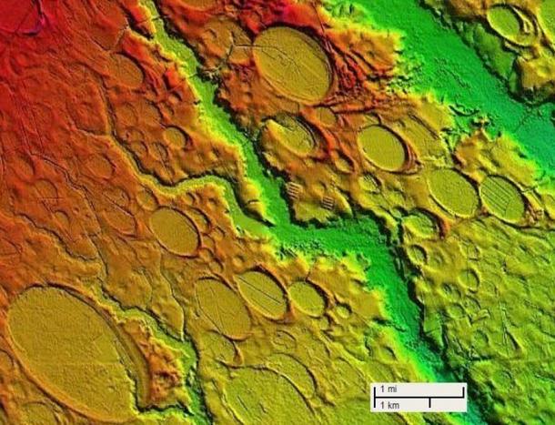 Craters within craters. Again, a strange arrangement for wind forces to create. Or any other known force.: 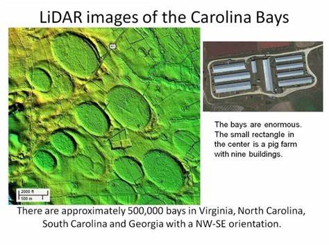 More images: 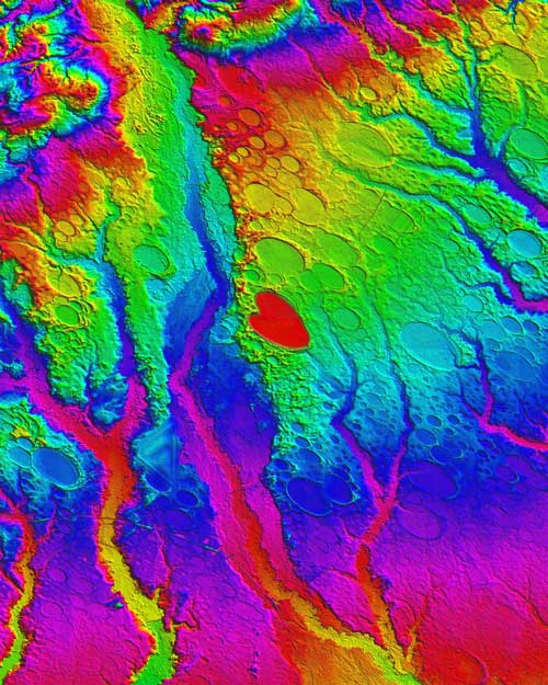 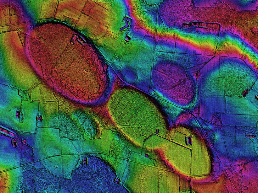  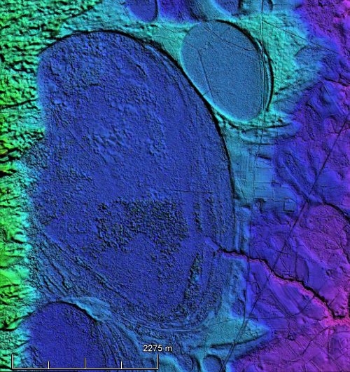  Soft soils in Nebraska at same distance as east coast bays from Michigan:  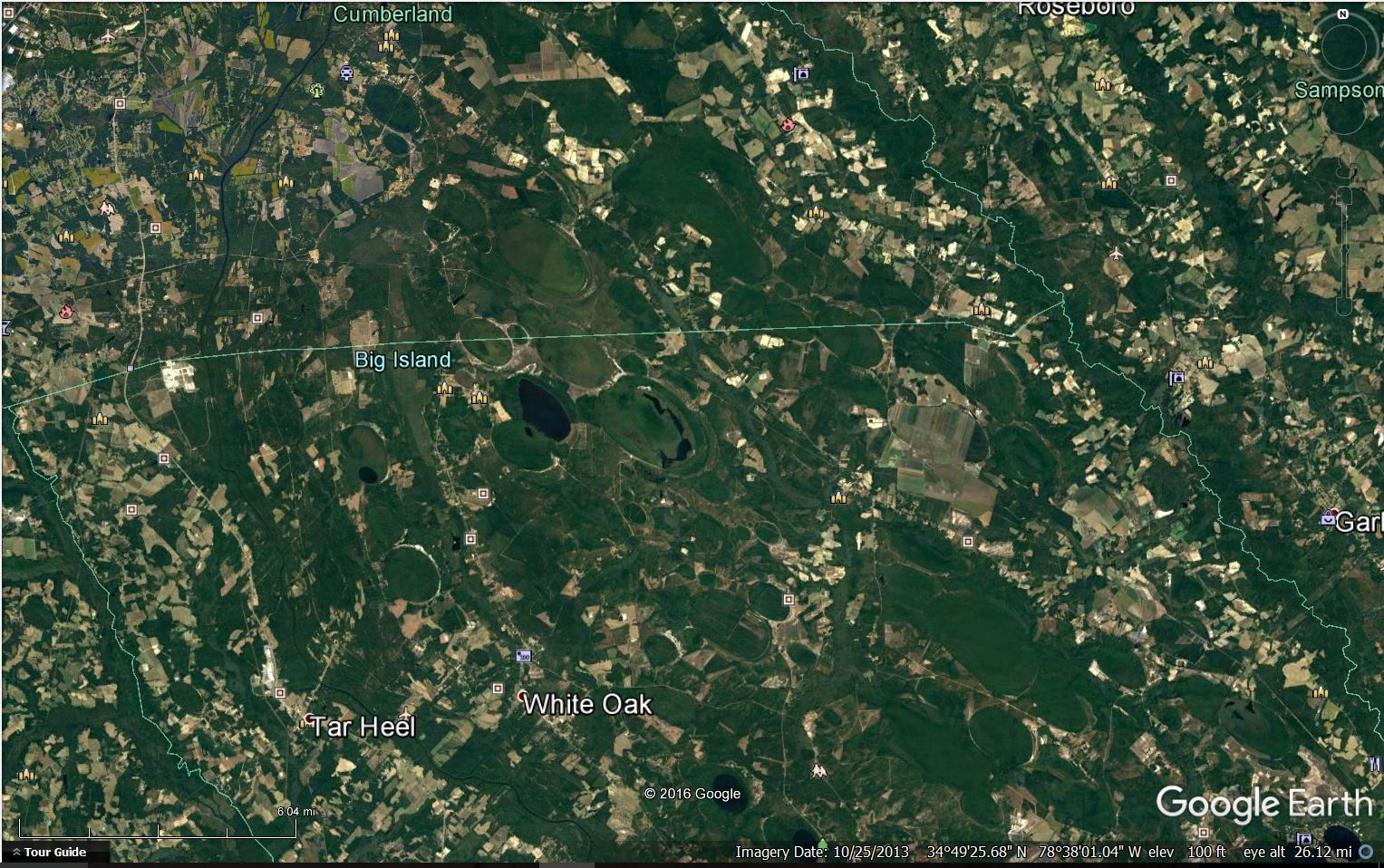 Note how the ovals rotate to a more northerly direction again toward Michigan as you move 200 miles west to Georgia from east at NC/SC state line. 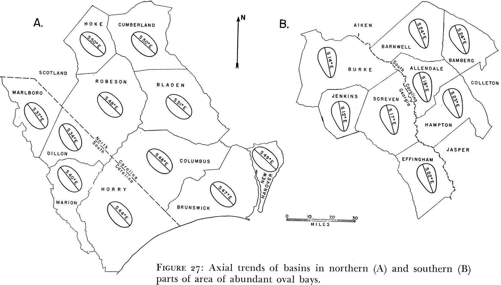 |
|


 on
on 


 Da Rules are up above in the Sales Department:


 You're down here in the bilges with the wharf rats. You will get more mileage above on the upper decks.