|
|
Post by mohs on May 7, 2022 21:26:35 GMT -5
Darn I vaguely recall that Logan Coal disaster
We have this major controversy going on here in Superior AZ
Mining copper on Oak Flats
Jobs jobs jobs supposedly
Do we really need to exploit this much copper
Or
is just money & technology grab
just to do something ?
wish they wouldn’t do it, mostly
|
|
|
|
Post by rockpickerforever on May 7, 2022 21:42:58 GMT -5
[Wrong article, Toots] Couldn’t have been much left to fix after the last one, Jean . . . they had a beautiful new infrastructure plan every two weeks. Rich, I think we have a bit of a disconnect here. I will admit I can be dense at times (especially when relaxing with an adult beverage in hand  .) But I don't always understand what point it is that you are trying to make. You are correct, not much left to fix after that one went, but that's not what I was typing about. Was typing about more recent dams, modern day ones, not 100 year old ones. Oroville is one (it's only 54 years old) and bridges, most recently there was one back east that needed to be repaired. It wasn't repaired, it failed. Let me know what you are talking about, and I'll try to respond in kind. |
|
|
|
Post by parfive on May 7, 2022 22:26:01 GMT -5
Well, Jean . . .
1. You quoted the Colorado reservoir article which wasn’t concerned w/dam safety and then riffed on dam safety, and
2. you ragged on Brandon’s infrastructure spending while conveniently forgetting the maggot’s absolute lack thereof.
|
|
|
|
Post by vegasjames on May 7, 2022 22:45:16 GMT -5
Darn I vaguely recall that Logan Coal disaster We have this major controversy going on here in Superior AZ Mining copper on Oak Flats Jobs jobs jobs supposedly Do we really need to exploit this much copper Or is just money & technology grab just to do something ? wish they wouldn’t do it, mostly Found this one with more details
|
|
|
|
Post by amygdule on May 7, 2022 22:47:50 GMT -5
I like Popcorn  One of my favorite ManMade Disasters |
|
|
|
Post by rockpickerforever on May 8, 2022 1:18:12 GMT -5
Well, Jean . . . 1. You quoted the Colorado reservoir article which wasn’t concerned w/dam safety and then riffed on dam safety, and 2. you ragged on Brandon’s infrastructure spending while conveniently forgetting the maggot’s absolute lack thereof. 1. No, I quoted your post which had a link in it. I did not quote anything from that link, I never even opened it. 2. Please forget about infrastructure and that guy named Brandon.I can't comment on it for fear someone may get their feelers hurt. |
|
|
|
Post by mohs on May 8, 2022 2:32:08 GMT -5
Well Now .?.. that puts a new spin on
Drill,baby,drill
Mostly
|
|
|
|
Post by parfive on May 8, 2022 2:33:07 GMT -5
I quoted your post which had a link in it. I did not quote anything from that link, I never even opened it. So why quote the post/link when it had f'all to do with . . . |
|
|
|
Post by amygdule on May 8, 2022 2:47:20 GMT -5
"One of the Worst Man-Made Disasters in History"
|
|
|
|
Post by rockjunquie on May 8, 2022 4:08:10 GMT -5
Jean and Rich, rockpickerforever and parfive- This thread has been far too interesting to have to nuke it or send it to the Cave. Please know that you have both made your points and no further escalation is necessary. When it comes to disasters, there is usually plenty of blame to go around- either for the disaster or the aftermath, or both. |
|
jamesp
Cave Dweller 
Member since October 2012
Posts: 36,154
|
Post by jamesp on May 8, 2022 9:52:45 GMT -5
Most dam failures are related to floods caused by too much precipitation or snow melt. The Dog River in Douglas County Ga. flooded when a freak 21 inches of rain fell in less than 24 hours. This was 6 times more water than a 100 year flood event which might be pushing the record for an extreme flood event. All it takes is for a landfall hurricane to pause for a day like Opal did back in 2009 in Georgia and took dams out all over the state including a large Lake Blackshear dam. This photo shows a flat section of the river where the water velocity was slow compared to other sections of the river. Note patch of bark removed from pinetree at upper left. 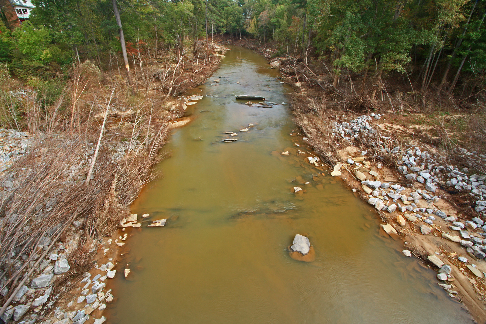 Much of this river flows thru gorges with steep walls where every tree was completely stripped of bark 40 feet up due the the high water velocity and debris in the water. Chunks of granite as big as a school bus were lifted out of the river bottom. The tips of corn tassels were sticking up out of the sand where corn fields were covered with 6 to 8 feet of sand and rock. At the sharp turns in the river the water tried to go straight and went 150 feet up the hillside and removed all the trees on them. Me and a friend kayaked an 8 mile section of it as soon as the water level returned to average level. We were stunned at the damage done to the bedrock river bottom. It was unrecognizable. A beautiful well established Appalachian river basically destroyed. The river rarely exceeds 100 foot drop in a 1000 feet so it does not have extreme fall. Oroville in 2017, Glen Canyon in 1983 are massive dams that had close calls with erosion(Oroville) and cavitation(Glen Canyon) due to floods. These are well engineered dams. Freak storm 2009. Why ? Yellow area is Douglas County, red star is Atlanta. Some sections of the county received 21 inches. 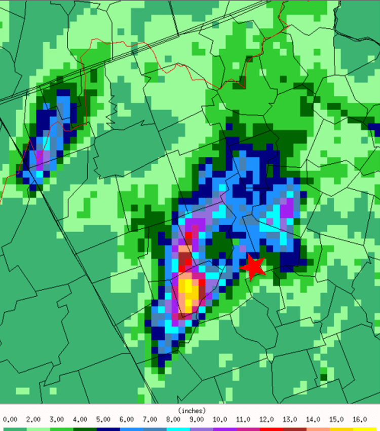 Man standing next to river for reference. This is also a flat section of the river.  Judging from the shredded foliage it looks like the river rose about 20 feet at this wide section as opposed to 40 feet at narrower sections(where dams are typically built). Little erosion here due to the lower water velocity. 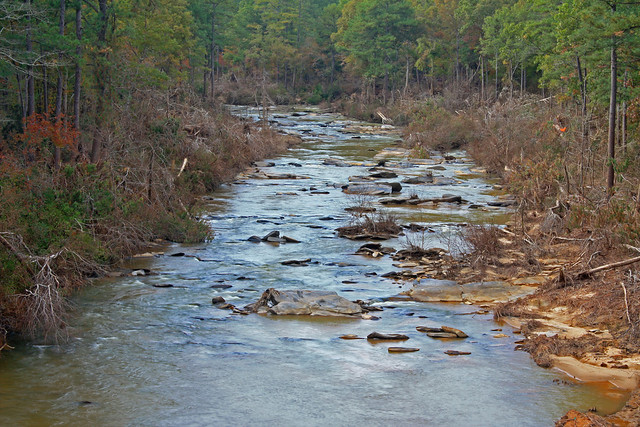 |
|
|
|
Post by parfive on May 8, 2022 11:38:19 GMT -5
|
|
pizzano
Cave Dweller
Member since February 2018
Posts: 1,390
|
Post by pizzano on May 8, 2022 13:35:09 GMT -5
Dam failures are not that common here in the US and the loss of life due to failures in our country are relatively small in relationship to those disasters other countries have experienced.......and it's not the dam it's self that generally fails, it's the poor and inadequate spillway designs, construction and maintenance that have caused most of the breech issues...regardless of the impact of any storm event.
There are three specific types of man-made structures that are the most scrutinized during the design and construction aspects in our country, bridges, high-rise buildings and dams (nuclear power plants also qualify)......today, each go through a long and tedious environmental (Federal, State and County) application process, land acquisition and Geotechnical evaluations.....prior to any real technical engineering design aspects.......all of which may take as long as 10yrs to complete, regardless of the location (one exception would be the state of Texas, where there are more than 7,000 of them & only one natural lake bed among them).
There are many types and purposes of dam design.........arch, buttress, coffer, diversion, embankment, gravity, saddle, regulating........each generally constructed with building materials such as earth, concrete reinforced, brick and mortar, boulder & rock, even steel & wood.
Not all designed for the same purposes in mind......storage, power, diversion, travel, irrigation, protection and aesthetic.
Man who settled in Europe and the North America's first learned and applied dam applications by studying wildlife......noticing that the stream, creek or river they had settled near, suddenly changed course or had been reduced by changes that were not due to any weather occurrence.......Beavers are master dam builders...!
Regardless of use and or application, spillways are always implemented (or at least should have been) in the design and construction of any dam.......purposely included as a relief aspect to control/manage discharge and capacity limitations........here in-lies the dam failure aspects.
Having been a party to and designer/construction inspector/surveyor & quality control project manager on two dam projects during my civil engineering career, the Prado Dam expansion in Riverside County, and the 7 Oaks Dam project in San Bernardino County.......both of which have had a negative impacts on the Santa Ana River confluence........I can speak to some of the various problem areas of the design aspects.
As with most civil engineering design projects, after the planning and preliminary concepts have been dialed-in and approved, design actually begins. Teams of expertise are established and put to task.......it's suppose to be a coordinated and controlled effort......not always the case when one aspect of the project design gets or has been accelerated further along due to various efforts being applied by outside influences........such was the case with the 7 Oaks project. There were 4 major design teams associated with it's design (in layman's terms), the structural, the plumbing, the electrical and the geotechnical. The spillway aspects were most effected by the structural and geotechnical divisions.........capacity, hydrology, hydraulics, had all been determined until geotechnical ran across a problem.
Outside influences (politics) caused design aspects to change......was it suppose to be a flood control/management design or was it going to be a reservoir storage and distribution design.......this issue cropped up it's ugly head 2/3rds into the design completion......an earth/rock and boulder gravity fed facility...the largest of it's kind in North America.....!.......now, it was to be reconsidered as a reservoir......without going through the proper environmental processing for such...legally.......lol
Long story short.......the spillways were now to serve different purposes......rather than just relief discharge facilities, now to be designed as distribution channels........that's where geotechnical found the problems..........no one had even considered this aspect up until the water quality control experts stepped in after the geotech analysis was performed........to much ancient biological matter/formation to support structural integrity without removing such........at depths and widths no one had any funds to perform........and no place to incorporate the material within it's approved projects limits.....the clock was ticking and Federal Funding deadlines had passed.
With dam design, it's not uncommon for the spillways to be an after thought.......particularly if only being designed as relief mechanisms.......not as potable water discharge facilities.....a whole different set of values assigned to that design.....water quality, maintenance, distribution quantity, operation time frames, monitoring......ect, ect, ect.......!
So, one may now realize, from reading this, that several factors can become issues with dam spillway design & construction......not just the dam it's self....leading to the most common aspect of dam failures in this country.....!
|
|
jamesp
Cave Dweller
Member since October 2012
Posts: 36,154
|
Post by jamesp on May 8, 2022 16:30:21 GMT -5
parfive pizzanoAs long as the oceans, ground and air keep warming (for whatever reason) rest assured dams will be stressed by floods(and droughts). It is likely Glen Canyon dam may have failed had plywood not been added to the top of the dam. Engineers were seriously surprised by the reinforced concrete and rock removal rate(1000 cubic feet of concrete per minute)caused by cavitation in the overflow tunnel. Such a mass scale cavitation situation was difficult to simulate in a lab. "Glen Canyon Dam is a colossus on the Colorado River, second largest reservoir in North America. And it nearly failed in the floods of 1983. What saved it was an idea from Richard Fehr to use four feet of plywood to save the dam and the Grand Canyon below the lake." The 21 inch flash rain in Douglas County also washed out substantial road bridges all over the county and took 3 years to replace several bridges with DOT spec bridges. Bridges easier to replace than dams. The mind blower was the damage in the gorges where the flood water was 40 feet deep and travelling at much higher velocity as opposed to the flatter sections of the river where the flood water was only 20 feet deep at lower velocity. As long as there is no loss of life or property damage no one was concerned and no studies made on the severe geologic effects. The fisherman and kayak folks noticed, so what. This was one of the most extreme and rare small scale flood events that seriously damaged granite bedrock that should have been of great interest to geologists. A 10 mile diameter storm parked over my place about 15 years ago dumping 6 inches of rain in one hour. This little flood also surpassed a 1000 year flood event and nothing was ever said, too small an area to make the news. Local damage was incredible. The old timer 3rd and 4th generation farmers had never seen anything like it. The US has just been fortunate to have these types of increasingly worse rain events to not happen where large dams are located. Other countries have not been so fortunate. Floods are on the increase in past decades. Our dams and bridges were not built for these conditions. 
|
|
jamesp
Cave Dweller
Member since October 2012
Posts: 36,154
|
Post by jamesp on May 8, 2022 17:05:33 GMT -5
pizzano Joe, must be that 9 out of 10 dam failures in this area are due to the overflow system failures caused by floods. Be them small or rather large, it always seems to be the weak link. They underestimated the rate of bedrock erosion resistance during the Oroville flood and had to open up the long concrete ramp overflow which was severely damaged too. Improvements in design have been incorporated, many improvements forced by damages caused by real world flood events. Flood events happen over amazingly short periods of time and can be so unpredictable in intensity making them so dangerous. "Maria was among the top 10 wettest hurricanes to ever to hit the United States. Since Maria was the most powerful hurricane to strike Puerto Rico since 1928, it is no shock that it produced the heaviest rain during the study period, but there is more to the story. At the beginning of the observational record in the 1950s, a storm like Maria was likely to drop the peak observed rain of 40.51" once every 300 years. But in 2017, that recurrence interval dropped to about once every 100 years, according to the study." Recent slow moving larger hurricanes have dropped 30 inches of rain in the south east. Used to be that 20 inches was the high end.
|
|
jamesp
Cave Dweller
Member since October 2012
Posts: 36,154
|
Post by jamesp on May 8, 2022 17:17:52 GMT -5
All three of those states have the worst flood threat - slow moving landfall hurricanes. Opal brought it's heavy rains way inland. A 500 foot elevation ridge 5 miles from the house got hit by about a dozen spin-off tornadoes over it's 3 mile length in 1995. The hill(named Oak Hill) was covered with 50-60 year old oaks and those tornadoes laid 80% of them over. This was also in Douglas County before the 2009 flood. 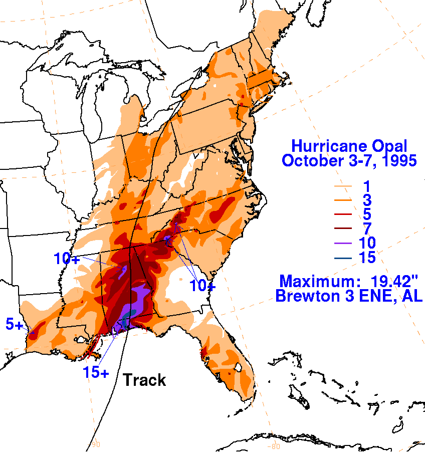 |
|
|
|
Post by parfive on May 8, 2022 17:30:19 GMT -5
. . . (for whatever reason) . . . [chuckle] Easy to get an inch of rain in ten or twelve minutes these days. I got hammered by the tail end of Ida last September and local rain gauges recorded over seven inches an hour. |
|
jamesp
Cave Dweller
Member since October 2012
Posts: 36,154
|
Post by jamesp on May 8, 2022 18:17:46 GMT -5
. . . (for whatever reason) . . . [chuckle] Easy to get an inch of rain in ten or twelve minutes these days. I got hammered by the tail end of Ida last September and local rain gauges recorded over seven inches an hour. Dodging climate bomb lol. A fast inch in 10 minutes is one thing, when it persists at that rate for an hour groundwater gets interesting in a hurry. Seems like the entire east coast has been getting hammered by Gulf hurricane residue in recent years. |
|
pizzano
Cave Dweller
Member since February 2018
Posts: 1,390
|
Post by pizzano on May 8, 2022 19:45:33 GMT -5
Completely agree James, with climate changes being as drastic as they have been within even regions that historically experience higher rates of precipitation annually, than say the Southwest regions.......Remember, it's not only the volume, rate or frequency of precipitation per hour, per 24hr, per week, per month, per year, per 10yr or even per 100yr event, that contributes to storage facility failure......!
It also involves how that volume contributes to discharge velocity rates that move earth, rock, trees, hills & mountains.....that in-turn, change the water shed capacity and flows of direction, due to the "debris" that builds up, fills up/reduces historical, previously predictable volume capacity tables........water travelling on an earthen surface with less than a 1% grade, can and will exceed erodible velocities of 5fps if given enough liquid volume, which is enough to displace earth.
The capacity of earthen water storage facilities are designed with several and multiple extreme/over the accepted safety limit variables (factors).....just like highways are designed be traveled on with a safety factor of 10 or more mph, than the posted speed limit........particularly, those that carry heavy traffic, experience volumes of rainfall/snow/ice and are posted with more than a 45mph speed limit.
Dams and spillways are no different......the designs are based on regional "historical" worst case scenarios, with, in some cases, factors as large as +50% greater than, which were implemented during the design and construction.......in many of the cases you have mentioned, those "historical" worst case scenarios were exceeded by more than 100% of what had been experienced in the last +100yrs........and in some of those cases, previous land development, fires, highways, mining, agriculture, forestry decline or overgrowth, contributed to the changes within the existing and historical watershed capacities implemented in the original dam development....and or may have been the reason the dams were put in-place to begin with.....!
As engineers, we can only base our designs on probabilities and expectations, through our (and other's) previous experiences......and add all of the safety and plus factors as practically, economically, technologically possible.......many of those "failures" mentioned, were most likely not the fault of the design implemented at the time of construction......but, rather the result of Mother Natures (and a few man-made changes), that exceeded even the best and most formable applications used at the time of construction......if we all had crystal balls and ability to see into the future, there would be no need for Flood Insurance or Government oversight and permit applications........lol
|
|
|
|
Post by mohs on May 8, 2022 20:13:37 GMT -5
just thought I stop by and say buute I have thee creeeestal ball cosmic debris m  stly |
|


 .) But I don't always understand what point it is that you are trying to make.


 stly
stly 


