

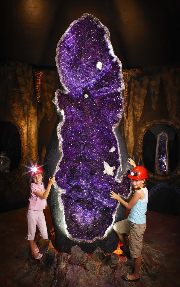
Brazilian Cathedral Amethyst Geodes
Feb 6, 2015 15:39:02 GMT -5
rockjunquie, snowmom, and 1 more like this
Post by 1dave on Feb 6, 2015 15:39:02 GMT -5
Southern Brazil and Uruguay is the only place on earth where these amazing structures are known to have been formed.
What unusual conditions permitted their creation?
Quotes are from:
Geochemical and scintillometric characterization and correlation of amethyst geode-bearing Paraná lavas from the Quaraí and Los Catalanes districts, Brazil and Uruguay
1. 160 Million Years ago, The Botucatu Formation covered the then joined land that is now Brazil and Africa. It is made up of aeolian sandstones formed in a large erg (sand sea or dune sea) in the Cretaceous, possibly the largest erg in Earth history ( Scherer, 2000 ). These sandstones and the underlying Guara Formation sandstones today constitute the huge Guarani aquifer (Araujo, Franca li. Potter, I999; Soares, Soares & Holz, 2008).
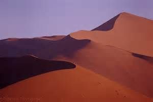
SandDunes.jpg
The way the world was 135 Million years ago in Brazil and Uruguay.
2. The two land masses began pulling apart.
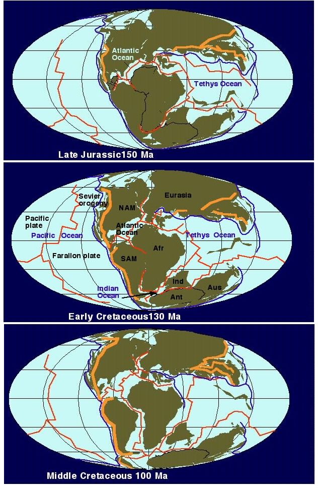
3. 135 million years ago huge volumes of flood basalts (light gray in the map below) raced over much of the area.
4. Sand and steam geysers blasted through the still liquid basalt layers.
The water table in the desert was probably near the surface as in the Sahara and Kalahari deserts today, so sealing by a lava flow very likely filled the aquifer in a short time, perhaps thousands of years.
Filling of the erg‘s topographic basin (widespread ergs occur in topographic lows) with lavas sealed the aquifer and residual volcanic heat caused the intrusion of dykes and sills of liquefied sand with the formation of sand volcanoes and flows on top of the lavas. Clastic sand dykes and sills are common in the volcanic sequence
A little about Lava:
At 1,200 degrees C, basalt is a very fluid liquid, but 200 degrees cooler it becomes a frozen solid.
However, as Mantle Material reaches the surface, it expands, and that makes it hotter. Flowing also increases its temperature, allowing thick layers of basalt to speed across vast distances before cooling begins.
Once it stops moving, lava cools very quickly on the surface and forms a thin crust that insulates the interior of the lava flow. As a result, basaltic lava flows can form crusts that are thick enough to walk on in 10-15 minutes, but the crystallization taking place inside also generates heat, so even thin flows can take several months to completely cool.
Because of the insulating properties of lava, the thicker it is, the slower it cools. A thick layer of lava, say 30 m or 100 ft, can take years to cool completely.
An example of thicker flow cooling is a Hawaiian lava flow that erupted in 1959 and partly filled a pit crater (Kilauea Iki) about 85 meters thick ( 280 ft). When it was drilled in 1988, 29 years after it erupted, it was still a little mushy near the bottom.
MFA-BasaltDiagram-my.jpg
A closer look at the elongated amygdaloid lava flows:
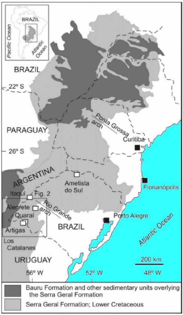
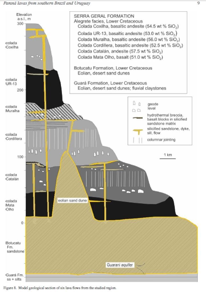
The total volume of lavas extruded in the Serra Geral Formation was estimated by Frank, Gomes & Formoso (2009) at 450,000 km2 with an additional volume of 122, 000 km2 in sills. It has a maximum preserved thickness of 1700 m at the center of the Parana basin. Each lava unit has a thickness between 5 and 80 m (average 20 m; Peate er al. 1999) and the total number of preserved lava flows is close to 120.
Evidence of lava imprint on the surface of sand dunes is observed in the Quarai region, similar to other exposures in the province (Petry er al. 2007; Waichel er al. 2006; Waichel, Scherer & Frank, 2008).
1B. Colada Mata Olho, The thickness of colada Mata Olho varies between 10 and 15 m, as measured in four boreholes. The least siliceous lavas such as colada Mata Olho and colada UR-13 have the structure of pahoehoe lavas, including the absence of brecciated crusts.
Along the BR-293 highway, coladas Mata Olho, Catalán and Cordillera overstepped the sand dunes in palaeohighs as shown by the evidence of the direct contact of each lava with the Botucatu Formation sandstone. The added thickness of the three lavas indicates an estimated 100 m elevation for the Cretaceous dune (Fig. 8). This is comparable to the height of some of the modern dunes in the Kalahari desert.
2B. Colada Catalán, directly overlies the sandstones in the basaltic cuesta situated in the northeastern Los Catalanes gemological district, but regionally it is the second lava.
Colada Catalán was given special attention because it has the structure of aa lava (Fig. 4); it has locally a basal crust and a massive core, and everywhere an upper crust and typical contorted flow banding over large distances. The crusts are made up of breccias of vesiculated lava, whereas the core is thick and contains the elongated amethyst geode deposits of colada Catalán in the Los Catalanes gemological district and in Garimpo do Vivi (Fig. 2), Quaraí mining district.
An impressive 1–3 m thick autobreccia, formed during lava emplacement, marks colada Catalán in its upper crust and along most of its 50 × 50 km observed extent (possibly 200 km), with angular blocks and variable cement, as first described in Garimpo do Vivi by Augustin (2007). The breccia blocks are locally immersed in silicified sandstone stockwork, which is invariably in contact with a 0.5–2.0 m thick, lilicified sandstone at the top. Autobreccia lacking sandstone is more abundant and has no sandstone layer on top; the upper contact where observed is with colada Cordillera.
The flow is approximately 30–70 m thick (Figs 6, 7) and its upper breccia portion has a distinctive appearance both in satellite images and in the field, because it consists of 100–300 m wide, 1000–2000 m long, ribbons of light grey (in satellite images) rocks alternating with green (in satellite images) grassland portions.
3B. Colada Cordillera, In other places, colada Catalán and colada Cordillera are in direct contact with the eolian sandstones. Colada Cordillera (20–60 m thick, Fig. 6) hosts the world-class amethyst geode deposits in the Los Catalanes gemological district, but no mineralization is known on the Brazilian side of the border. The structure of the mineralized flow (Fig. 5) consists of upper (10 m thick) and lower (5 m thick) amygdaloidal crusts with a massive core divided into two portions. The upper part of the core is 20 m thick, displays columnar jointing and is not mineralized, whereas the lower part (10 m thick) is not jointed and contains the large deposits of geodes.
This structure was described in the field and confirmed by chemical analyses of the rocks and scintillometric measurements. This is a novel type of lava structure previously unknown in the Paraná volcanic province.
4B. Colada Muralha is approximately 30–60 mthick and is mostly massive with amygdaloidal lower and upper crusts with a massive core (Fig. 6). It has the structure of aa lava, but was less studied than coladas Catalán and Cordillera because it covers a smaller area. Colada Muralha is exposed at the surface in four boreholes (Fig. 6) and was probably eroded in the others.
5B. Colada UR-13 was first identified in borehole UR- 13 (Fig. 7) which drilled all six lavas, and was then
confirmed by chemical analyses of outcrop samples. Its thickness is near 60 m in the borehole (Fig. 7).
6B. Colada Coxilha was little studied because it only occurs in one hill in the northern part of the region and in borehole UR-13 (Fig. 7); it is approximately 60 m thick and has amygdaloidal lower and upper crusts.
Because colada Coxilha caps the hills in the region, the upper amygdaloidal crust has been mostly removed by erosion.
The bubble walls were basalt containing in %:
Colada - name . . . . . . . . . . . . . . SiO2 . . . . MgO . . . . CaO . . . . K2O . . . . Cr2O3 . . . . TiO2 . . . . P2O5
Cordillera - Basaltic andesite . . . 52.50 . . . 6.0 . . . . . 10.0 . . . . 0.90 . . . . . 0.40 . . . . . 1.1 . . . . . 0.15
BUT because of the sand geysers, dykes and sills, they probably contained far more SiO2 than normal!
Most of the bubbles contained steam, but probably some of them also contained blown in silica sand.
What happened to that sand?
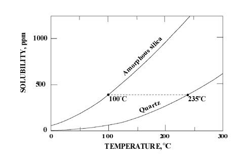
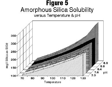
QuartzSolubilityH2O.jpg
The only SiO2 Solubility charts I have stop at around 300 degrees C, but those sand filled bubbles were in magmas at +1200!
Perhaps 5,000 to 10,000 parts per million?
Heating the bubbles would have chilled the enclosing magma, so I think the forming shells would have been highly enriched with silica.
The layers solidified, cooled and contracted, and as steam became water, the bubbles became vacuum chambers.
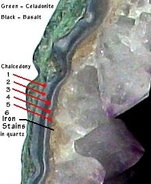
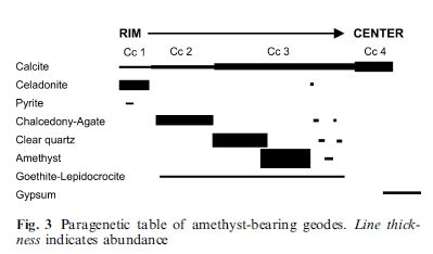
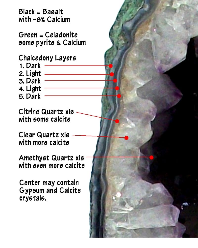
5. The bubbles filled with water 60 million years later, which finally began altering the basalt walls into the low grade metamorphic mica mineral celadonite (from the French celadon, for sea-green).
K(Mg,Fe++)(Fe+++,Al)[Si4O10](OH)2
It crystallizes in the monoclinic system and usually forms massive aggregates of prismatic crystallites or in dull clay masses. It is soft with a Mohs hardness of 2 and a specific gravity of 3. Typically occurs as dull gray-green to bluish green masses. It forms vesicle fillings and linings in altered basaltic lavas.
So the green outer coating is not something that was brought into the geode, it is the altered remains of the original Basalt walls.
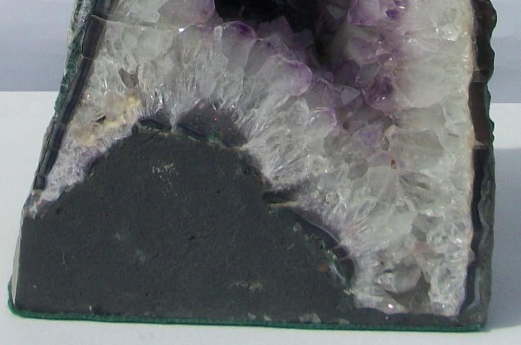
01-2015-02-05-Feb-CG 008CB.jpg
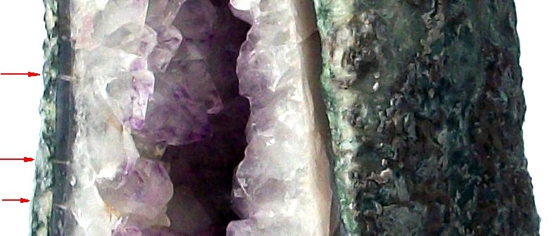
Note the pile of celadonite that has fallen to the bottom. - - Note also that the layers of chalcedony formed on top of the pile on the bottom, but it was broken up before the quartz crystals began to form.
6. Finally SiO2 is leached from the surrounding basalt and sand dykes and sills and begins crystallizing within the bubbles. PH is very important in solubility and probably in crystallization.
Si02Solubility.JPG
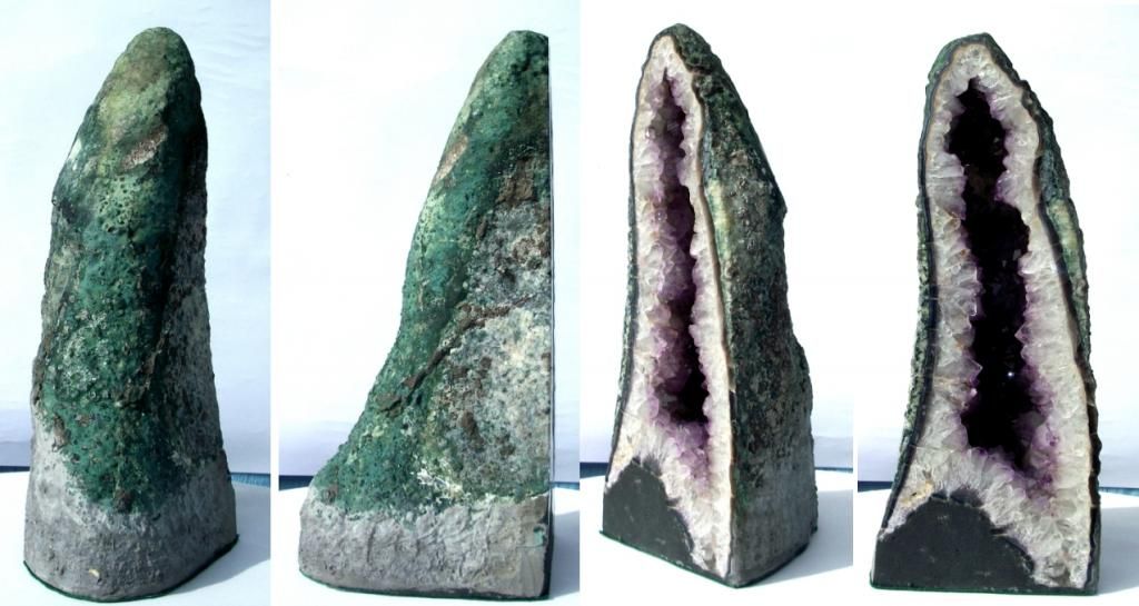
01-2015-02-05-Feb-CG01.JPG
4 views of a typical Cathedral Geode. Note how wide it is at the base, the green outer shell, and pile of green in the base. The gray around the base is cement to keep the soft celadonite from falling apart.
01-2015-02-05-Feb-CG 007CaF.jpg
Note the fill tubes.
01-2015-02-05-Feb-CG08accsn.jpg
Conclusions: Formed by 6 unique conditions.
1. Sand Dune Desert.
2. Continents pulled apart.
3. Basalts covered sand aquifers.
4. Water turned to steam and blasted sand through layers of basalt and filled them with bubbles.
5. Bubbles remained empty for 60 million years, then filled with water that started changing basalt into celadonite.
6. After a long time silica became concentrated in the cavities and crystallized in layers of chalcedony, then quartz crystals, then finally amethyst quartz.


 I noticed they never adhered cement, is this normal for Brazilians?


 Serious thought goes into a Chat Box v.2 post. "It Ain’t Easy"
