|
|
Post by fantastic5 on Feb 12, 2018 9:44:43 GMT -5
So fernwood 's thread about dying petosky stones (great experement BTW) had me thinking about Tidy Bowl used to color howelite. Which made me think about the 'blue ice' mystery of Signal Mountain, Tn. My DH calls this spaghetti thinking - that everything in a women's mind is linked to everything else. The last several years we have had blue icicles forming on the side of the W Road. My theory has always been kids putting Tidy Bowl cakes in places the water will flow over. My kids and I have been guilty of putting powdered sugar-free Koolaid to make rainbow icicles along the road too, but they are not nearly as vibrant as the blue. This winter it even made local news. Plus it is a pretty good shot of what the historic W Road looks like. There are no dividing lines in the curves because only one car can fit at a time. No signs warn of this, and us locals can negotiate these in our sleep. But anyone who is not used to the turns really puts on a show  |
|
|
|
Post by Pat on Feb 12, 2018 10:05:15 GMT -5
Cool!
I've never lived anywhere that produced ice-cicles. Very pretty.
|
|
|
|
Post by mohs on Feb 12, 2018 10:38:35 GMT -5
very cool serious switchbacks spaghetti thinking  my meatball can capice that  eddie spaghetti mama mia mostly |
|
|
|
Post by MsAli on Feb 12, 2018 10:47:33 GMT -5
|
|
|
|
Post by mohs on Feb 12, 2018 10:57:47 GMT -5
Facetnating! light, colors, reflections ect 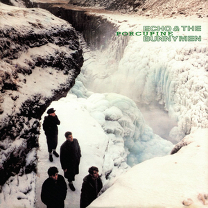 One of my favorite album covers from decades ago recalled Ice bluesness |
|
|
|
Post by MsAli on Feb 12, 2018 11:13:36 GMT -5
Facetnating! light, colors, reflections ect One of my favorite album covers from decades ago recalled Ice bluesness
Ah now I've got this song in my head.....
|
|
|
|
Post by fernwood on Feb 12, 2018 11:18:39 GMT -5
Thanks for sharing. I used to live near Menomonie, WI. There was a undeveloped area along the Red Cedar River called Paradise Valley. Huge cliffs and streams running through it. In the winter, there were massive blue icicles and ice caves. This was attributed to copper and other minerals present. Brought back memories.
|
|
|
|
Post by rockjunquie on Feb 12, 2018 13:14:52 GMT -5
So pretty! I'd have to stop for pictures, too.
|
|
wannabee
starting to spend too much on rocks

Member since September 2016
Posts: 188 
|
Post by wannabee on Feb 12, 2018 14:48:52 GMT -5
I frequently see ice forming where the New York Thruway (I-87 & I-90) cuts through the bedrock. The cut throughs always weep water, so in the winter they form these really cool walls of ice. 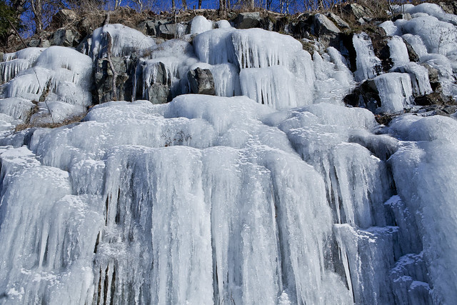 Sometimes it has a very distinct blue tint to it, especially in the Herkimer - Canajoharie region. I don't know if it is due to some mineral content or what. It just looks pretty. |
|
|
|
Post by fantastic5 on Feb 12, 2018 15:53:40 GMT -5
I frequently see ice forming where the New York Thruway (I-87 & I-90) cuts through the bedrock. The cut throughs always weep water, so in the winter they form these really cool walls of ice. Sometimes it has a very distinct blue tint to it, especially in the Herkimer - Canajoharie region. I don't know if it is due to some mineral content or what. It just looks pretty. We're pretty much just the land of limestone, without much else (at least Signal Mountain). We have a few abandoned coal mines, but I've never seen any indication of anything but limestone where the road comes up the mountain. Here's a pic from summertime thanks to good ol'Google. The main portion of the blue ice was located in the curve straight ahead. 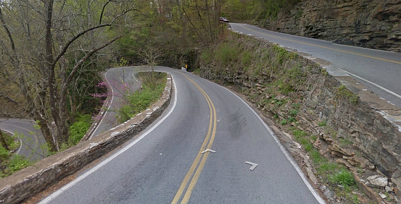 ETA - I wish we had Herkimers here! |
|
|
|
Post by wigglinrocks on Feb 12, 2018 16:40:16 GMT -5
We're pretty much just the land of limestone, without much else (at least Signal Mountain). We have a few abandoned coal mines, but I've never seen any indication of anything but limestone where the road comes up the mountain. Here's a pic from summertime thanks to good ol'Google. The main portion of the blue ice was located in the curve straight ahead. Now that looks like a fun road to drive , NOT ! |
|
|
|
Post by Garage Rocker on Feb 12, 2018 17:04:37 GMT -5
We're pretty much just the land of limestone, without much else (at least Signal Mountain). We have a few abandoned coal mines, but I've never seen any indication of anything but limestone where the road comes up the mountain. Here's a pic from summertime thanks to good ol'Google. The main portion of the blue ice was located in the curve straight ahead. Now that looks like a fun road to drive , NOT ! You know the curves are bad when you look out your window and see the back of your car beside you! |
|
|
|
Post by fantastic5 on Feb 12, 2018 20:55:03 GMT -5
Now that looks like a fun road to drive , NOT ! You know the curves are bad when you look out your window and see the back of your car beside you! Better than looking behind you and seeing the back end of your car resting on one of the walls. LOL Watched a newby to the road try to make the turn by staying in what would be their lane. Put the rear end right up on the wall, rear tire up in the air. Ends of each wall in the corners have been repaired so many times. The concrete never even has the chance to age. Always bright white. Noticed tonight on the way home one of the newly replaced end caps was knocked free. |
|
|
|
Post by fantastic5 on Feb 12, 2018 21:09:16 GMT -5
We're pretty much just the land of limestone, without much else (at least Signal Mountain). We have a few abandoned coal mines, but I've never seen any indication of anything but limestone where the road comes up the mountain. Here's a pic from summertime thanks to good ol'Google. The main portion of the blue ice was located in the curve straight ahead. Now that looks like a fun road to drive , NOT ! You know what wigglinrocks, it realy is FUN to drive! I grew up in Michigan where everything was flat and on a grid pattern. I've driven this road on and off for the 30+ years I've lived in the south, and nearly daily for the past 15. It is a beautiful road with rock worked added during the depression as part of the CCC. And stunning views too. What gets me is all the semi-trucks that just blindly follow their GPS and wind up on the road. Never mind the sign at the bottom, or at the first switch back less than 1/4 of the mile later. And lastly, the huge pull off before the gate at the beginning of the actual W's with the really big sign. But know, people just blindly follow the map app, because it can't be wrong. A couple of years ago we were following a full size U-haul truck with a full size flat bed car hauler up the mountain at night. My husband kept pulling into the oncoming lane, whenever he could, and was flashing his lights and honking his horn. A middle aged woman was white knuckling the steering wheel and wouldn't even look over at him. In front of her was a fully loaded pick up truck that I think she was following. So even before she got to the W's I called the local sheriffs office to let them know we were about to have the road blocked. Well, he stopped traffic at the entrance to top right away and was waiting on the lady as she came to the turns. He blessed her out about not reading the signs. Told her to get out of the truck, then preceded to get into the Uhaul and drive it to the top, leaving her standing in the road at the bottom. We were right behind them and he threw sparks all along the road from dragging the car hauler into the walls. I think he was tired of people blocking the road, so he just trashed the U Haul and car hauler and kept the road moving. I felt bad for the lady, but my husband thought it was hilarious. |
|
|
|
Post by wigglinrocks on Feb 12, 2018 22:28:40 GMT -5
Now that looks like a fun road to drive , NOT ! You know what wigglinrocks , it realy is FUN to drive! I grew up in Michigan where everything was flat and on a grid pattern. I've driven this road on and off for the 30+ years I've lived in the south, and nearly daily for the past 15. It is a beautiful road with rock worked added during the depression as part of the CCC. And stunning views too. What gets me is all the semi-trucks that just blindly follow their GPS and wind up on the road. Never mind the sign at the bottom, or at the first switch back less than 1/4 of the mile later. And lastly, the huge pull off before the gate at the beginning of the actual W's with the really big sign. But know, people just blindly follow the map app, because it can't be wrong. A couple of years ago we were following a full size U-haul truck with a full size flat bed car hauler up the mountain at night. My husband kept pulling into the oncoming lane, whenever he could, and was flashing his lights and honking his horn. A middle aged woman was white knuckling the steering wheel and wouldn't even look over at him. In front of her was a fully loaded pick up truck that I think she was following. So even before she got to the W's I called the local sheriffs office to let them know we were about to have the road blocked. Well, he stopped traffic at the entrance to top right away and was waiting on the lady as she came to the turns. He blessed her out about not reading the signs. Told her to get out of the truck, then preceded to get into the Uhaul and drive it to the top, leaving her standing in the road at the bottom. We were right behind them and he threw sparks all along the road from dragging the car hauler into the walls. I think he was tired of people blocking the road, so he just trashed the U Haul and car hauler and kept the road moving. I felt bad for the lady, but my husband thought it was hilarious. Yeah I can see it could be a fun road to drive . Just can't get the picture out of my mind what that road would look like this time of year in northern Wisconsin . Totally agree with you about the GPS believers , technology has erased a lot of common sense with a lot of people . |
|
|
|
Post by parfive on Feb 12, 2018 23:10:37 GMT -5
|
|
|
|
Post by fantastic5 on Feb 12, 2018 23:50:55 GMT -5
I wish most driver's on the W Road has a fraction of those truck drivers skills! The video of the trucks in the hairpin turns is a larger version of what we do in the W. Coming to a complete stop is usually not helpful if you are already in the turns. If both cars keep moving you can share the turn. |
|
|
|
Post by fantastic5 on Feb 13, 2018 7:50:50 GMT -5
Yeah I can see it could be a fun road to drive . Just can't get the picture out of my mind what that road would look like this time of year in northern Wisconsin . The road is gated at the top of the W's and where the rock work ends about a half mile later. So whenever it gets the least bit snowy or icy, they just close the road. Creates a bottle neck because there are only 3 roads off the mountain to Chattanooga, and they always close the W and Roberts Mill Gap road when the weather is bad. So everyone has to go down the 'front' as it is called. But the front road off the mountain may not have all the cool CCC rock work, but does have this house: 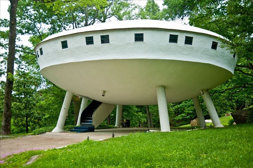 |
|
|
|
Post by fernwood on Feb 13, 2018 8:10:26 GMT -5
Awesome house. Just fly up and over the pass.
|
|
|
|
Post by wigglinrocks on Feb 13, 2018 9:03:47 GMT -5
Yeah I can see it could be a fun road to drive . Just can't get the picture out of my mind what that road would look like this time of year in northern Wisconsin . The road is gated at the top of the W's and where the rock work ends about a half mile later. So whenever it gets the least bit snowy or icy, they just close the road. Creates a bottle neck because there are only 3 roads off the mountain to Chattanooga, and they always close the W and Roberts Mill Gap road when the weather is bad. So everyone has to go down the 'front' as it is called. But the front road off the mountain may not have all the cool CCC rock work, but does have this house: Around here they wouldn't close the road . More like , if ya want to live in Wisconsin deal with it . Those CCC guys did some awesome things up in this neck of the woods also . Pretty cool house . Not sure about practical , but cool . |
|


 Al Falfa