jamesp
Cave Dweller 
Member since October 2012
Posts: 36,155
|
Post by jamesp on Sept 28, 2022 12:40:05 GMT -5
Wondering how captbob is faring in St Pete? He's going to be taking a pretty direct hit. Stay safe, captbob! This one will make history Jean. This would be the first time a hurricane has struck such a large urban area. Many near misses in the past, this one will be the real deal. Biden's climate budget is about to have a serious withdrawal of his soon-to-be misappropriated funds. Bob is vulnerable to flooding due to rain no doubt but he is north of the critical zone. The flood surge at the large(Charlotte)harbour at Fort Meyers and Punta Gorda will be the critical issue. Landfall is happening now with 155 mph winds plus the forward travel speed. 90F water along the coast, that is hot. The tide is coming in and peaking at 2:30pm adding to the surge. The east windwall is slamming Charlotte Harbour/Ft. Meyers at the worst possible angle for 18 - 20 foot storm surge. The surge will go well inland. Storm surge is responsible for 50% of the deaths and probably a higher percentage of the property damage. This is one of the most urbanized sections of the coast(Miami/Ft. Lauderdale is the largest). Charlotte Harbour has two deep inlets where rivers flow in from the east. Lots of waterfront real estate along these inlets. This hurricane seems similar to Michael back in 2018. Michael did not slow down at landfall much - non typical behavior and adds damage factor. Let's hope landfall slow this beast down. Then it tracks to the NEN across Orlando. It's track is running down high population zones. Nothing good about this one. |
|
|
|
Post by rockpickerforever on Sept 28, 2022 12:47:53 GMT -5
jamesp, Ian is going to be doing some heavy-duty rearranging of the landscape in that area. I pray for minimal loss of life and property, but this really is the real deal.
|
|
|
|
Post by RickB on Sept 28, 2022 13:11:03 GMT -5
When it's done with Florida they are projecting it to go into the Atlantic, make a second landfall around the Savannah/Hilton Head area, then through Columbia SC (me) while on it's way to Charlotte NC. Forecasters are now calling for 60 mph gusts in Columbia. Flash flood advisories/tropical storm warnings are coming out in our state. We used to have a condo timeshare in Fort Myers.
|
|
jamesp
Cave Dweller
Member since October 2012
Posts: 36,155
|
Post by jamesp on Sept 28, 2022 14:14:19 GMT -5
She said 4.1 feet was the worst surge tide they ever had at Charlotte Harbour due to effects of Irma a distance way.
They are expecting 18 feet, maybe 20 considering high tide influence because of the direct impact.
Oddly, they build whole cities based on historical surges when they know damn well any direct hit like this will quadruple+ the surge height. This event will bite them in the butt for such logic.
Ok, he just said(3pm) palm trees are snapped off mid trunk. That is unheard of wind force. A true wind force indicator.
Barrier islands JN Jing and Pine Island and Estero national refuge/Aquatic preserve add up to about 115 miles in length. You can probably kiss them goodbye. Sanibel Island should be wiped flat.
|
|
jamesp
Cave Dweller
Member since October 2012
Posts: 36,155
|
Post by jamesp on Sept 28, 2022 14:15:23 GMT -5
When it's done with Florida they are projecting it to go into the Atlantic, make a second landfall around the Savannah/Hilton Head area, then through Columbia SC (me) while on it's way to Charlotte NC. Forecasters are now calling for 50 mph winds in Columbia. Flash flood advisories/tropical storm warnings are coming out in our state. We used to have a condo timeshare in Fort Myers. Glad you sold your Ft Myers timeshare Rick. |
|
jamesp
Cave Dweller
Member since October 2012
Posts: 36,155
|
Post by jamesp on Sept 28, 2022 14:20:33 GMT -5
jamesp, Ian is going to be doing some heavy-duty rearranging of the landscape in that area. I pray for minimal loss of life and property, but this really is the real deal. Homestead Fl was hit by a smaller hurricane with similar wind speeds. Homestead has more greenhouses than about any place on earth. It looked like a giant pasture after strike. Thankfully rural. The barrier islands will be great treasure hunting after weather settles(if not underwater). Arrowheads galore. Pirate treasures. Sealed drug packages from past dumps and stashes. Old bottles. Those folks can use some prayers. People whom have lost their homes will be migrating into adjacent states. Atlanta was filled with Katrina survivors, crime came with them. Ft Myers is totally wealthy, maybe the mafia will migrate up here ! |
|
|
|
Post by rockpickerforever on Sept 28, 2022 14:40:03 GMT -5
Wondering how captbob is faring in St Pete? He's going to be taking a pretty direct hit. Stay safe, captbob ! This one will make history Jean. This would be the first time a hurricane has struck such a large urban area. Many near misses in the past, this one will be the real deal. Biden's climate budget is about to have a serious withdrawal of his soon-to-be misappropriated funds. Bob is vulnerable to flooding due to rain no doubt but he is north of the critical zone. The flood surge at the large(Charlotte)harbour at Fort Meyers and Punta Gorda will be the critical issue. Landfall is happening now with 155 mph winds plus the forward travel speed. 90F water along the coast, that is hot. The tide is coming in and peaking at 2:30pm adding to the surge. The east windwall is slamming Charlotte Harbour/Ft. Meyers at the worst possible angle for 18 - 20 foot storm surge. The surge will go well inland. Storm surge is responsible for 50% of the deaths and probably a higher percentage of the property damage. This is one of the most urbanized sections of the coast(Miami/Ft. Lauderdale is the largest). Charlotte Harbour has two deep inlets where rivers flow in from the east. Lots of waterfront real estate along these inlets. This hurricane seems similar to Michael back in 2018. Michael did not slow down at landfall much - non typical behavior and adds damage factor. Let's hope landfall slow this beast down. Then it tracks to the NEN across Orlando. It's track is running down high population zones. Nothing good about this one. Having never been there, I didn't know how St Pete sat on the (currently leeward side) of the peninsula. Had to look at a map and educate myself, lol. If the storm surge gets as high as they are predicting, being sheltered from the wind might still not protect St Pete. |
|
|
|
Post by mohs on Sept 28, 2022 14:40:10 GMT -5
not that it matters
butte I was in Orlando when Homestead was hit
being from zona it was the first experience
w/ hurricane in very vulnerable area
was in second floor apartment in Orlando
heck If the sea or even that lake rose
we were drowned rats
where the heck was I going to go ..mostly
I mean my ears would pop
at the highest point
which was the speed bump
gotta stay calm... mohs
anyway I recall that morning
looking out at the skies
as that Hurricane
was hitting 200 miles to the south
all calm
really eerie
luckily I never had TO put an X on the window pane
|
|
jamesp
Cave Dweller
Member since October 2012
Posts: 36,155
|
Post by jamesp on Sept 28, 2022 14:43:39 GMT -5
I had been concerned about powerful hurricanes this year due to these new warm waters of the Gulf of Mexico and in the Atlantic.
Fiona stayed a cat 4 unusually further north into normally cooler waters that calms them.
Ian passed over Cuba and did an increase from 140 to 155 mph in one hour. This is unheard of, especially at elevated cat 4 wind speeds.
God knows what will happen if one wonders up into the center of the Gulf like Katrina or Ivan did. Irma whipped up to a cat 5
|
|
|
|
Post by parfive on Sept 28, 2022 15:20:51 GMT -5
Mother nature’s been havin’ a fun year all around this little blue dot and the trend is not your friend.
|
|
|
|
Post by RickB on Sept 28, 2022 16:03:10 GMT -5
|
|
|
|
Post by hummingbirdstones on Sept 28, 2022 19:32:21 GMT -5
Ian may as well have been a cat 5. It was just 2 mph under that considering how big it is.
I hope all the folks dealing with this thing stay safe and come out ok in the end. I have to say, I've been impressed with DeSantis and his coordination between all the state and local governments, rescue workers, electric company people, etc. I've been watching on and off all day and have seen him a few times already giving press conferences that are full of information and what they are planning to do as soon as it's safe to do so. I have no doubt that even though a really large part of the state is going to be a huge mess, he will be on the job around the clock making sure everything that can humanly be done is being done.
|
|
|
|
Post by 1dave on Sept 28, 2022 20:15:32 GMT -5
oceanservice.noaa.gov/facts/ninonina.html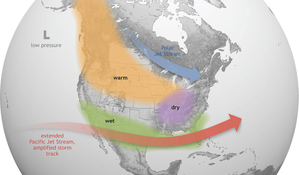 "El Niño causes the Pacific jet stream to move south and spread further east. During winter, this leads to wetter conditions than usual in the Southern U.S. and warmer and drier conditions in the North." My theory is under sea volcanoes heat the water, the hot water causes the storms. I've never heard anyone else try to find out if that is correct.
|
|
jamesp
Cave Dweller
Member since October 2012
Posts: 36,155
|
Post by jamesp on Sept 28, 2022 22:37:18 GMT -5
This one will make history Jean. This would be the first time a hurricane has struck such a large urban area. Many near misses in the past, this one will be the real deal. Biden's climate budget is about to have a serious withdrawal of his soon-to-be misappropriated funds. Bob is vulnerable to flooding due to rain no doubt but he is north of the critical zone. The flood surge at the large(Charlotte)harbour at Fort Meyers and Punta Gorda will be the critical issue. Landfall is happening now with 155 mph winds plus the forward travel speed. 90F water along the coast, that is hot. The tide is coming in and peaking at 2:30pm adding to the surge. The east windwall is slamming Charlotte Harbour/Ft. Meyers at the worst possible angle for 18 - 20 foot storm surge. The surge will go well inland. Storm surge is responsible for 50% of the deaths and probably a higher percentage of the property damage. This is one of the most urbanized sections of the coast(Miami/Ft. Lauderdale is the largest). Charlotte Harbour has two deep inlets where rivers flow in from the east. Lots of waterfront real estate along these inlets. This hurricane seems similar to Michael back in 2018. Michael did not slow down at landfall much - non typical behavior and adds damage factor. Let's hope landfall slow this beast down. Then it tracks to the NEN across Orlando. It's track is running down high population zones. Nothing good about this one. Having never been there, I didn't know how St Pete sat on the (currently leeward side) of the peninsula. Had to look at a map and educate myself, lol. If the storm surge gets as high as they are predicting, being sheltered from the wind might still not protect St Pete. They thought the east eyewall was going to hit Tampa Bay yesterday, overnight it shifted south to hitting Charlotte Harbour in the exact same way - eyewall straight into the inlet. The eyewall is rarely more than 10 miles wide so it is unusual for it to line up perfectly on an urban area like Ft Myers/Charlotte Harbour.. |
|
|
|
Post by parfive on Sept 28, 2022 22:40:23 GMT -5
Whatever. : )
Rare ‘triple dip’ La Niña declared
The Australian Bureau of Meteorology (BOM) has announced that the weather phenomenon La Niña has formed for the third consecutive year in the Pacific.
This is only the third time since records began that there have been three consecutive La Niña events.
"It is exceptional to have three consecutive years with a La Nina event," WMO Secretary-General Petteri Taalas said.
www.bbc.com/weather/features/62890361
|
|
jamesp
Cave Dweller
Member since October 2012
Posts: 36,155
|
Post by jamesp on Sept 28, 2022 22:48:34 GMT -5
Looking at a cat 1 as it passes over Orlando(crazy momentum, this thing is still loaded with energy).
Michael did the same thing in 2018, still a cat 2 almost 100 miles inshore, these inland wind strengths are modern trends.
The huge storms back in the mid 2000's slowed down rapidly even before landfall, dropping when half the eye was over land.
Inland Florida is in a bad place for this reason.
|
|
jamesp
Cave Dweller
Member since October 2012
Posts: 36,155
|
Post by jamesp on Sept 28, 2022 23:03:09 GMT -5
Heating Gulf stream is heating Greenland and related ocean currents from Antarctica are also heating. Heating causing north and south pole to lose cooling ice rapidly.    |
|
|
|
Post by parfive on Sept 29, 2022 0:17:19 GMT -5
Heating Gulf stream is heating Greenland and related ocean currents from Antarctica are also heating. Heating causing north and south pole to lose cooling ice rapidly. All this talk of heating, James, you got me thinkin’ . . . |
|
jamesp
Cave Dweller
Member since October 2012
Posts: 36,155
|
Post by jamesp on Sept 29, 2022 6:38:58 GMT -5
Heating Gulf stream is heating Greenland and related ocean currents from Antarctica are also heating. Heating causing north and south pole to lose cooling ice rapidly. All this talk of heating, James, you got me thinkin’ . . . One could say game on however there's not much opposition to this mysterious player. This event more mirrors a Humpty Dumpty theme. |
|
jamesp
Cave Dweller
Member since October 2012
Posts: 36,155
|
Post by jamesp on Sept 29, 2022 7:39:13 GMT -5
"My theory is under sea volcanoes heat the water, the hot water causes the storms. I've never heard anyone else try to find out if that is correct." Lots of theories out there 1dave with no answers. Yours makes perfect sense. The faults along the ocean bottom are 'thought' to put out 40(estimate)cubic miles of potentially superheated water per water per year. The earth holds 330,000,000 cubic miles of water, 140,000,000 square miles of water, good luck trying to know if such a large amount of water has risen 2F throughout its range much less what is causing it. No matter, the ice is melting and and the ocean sure seems to be rising and that's not good. A new climate analysis called 'tipping point' is being looked at. Perhaps the tipping point methodology will help predict the impacts of climate heating. It is based on analysing the oceans individually to check for domino effect relationships between them. Turbulent Jupiter's daily wind speeds are 900 mph. Earth is paradise compared to that planet. Maintaining our pleasant atmosphere is a miracle of balance. No matter, the guys with the world's wealth have made their conclusion. Reversing that conclusion will be more challenging than cooling the oceans. As if those guys can do a damn thing to cool 330 million gallons of water.(the big deception) "Fools and their money shall soon part" leaving the rest of us in a bad place. Unfortunately they are not fools but have other uses in mind for that wealth. Keep an eye on upcoming hurricanes. In the past century their impact locations have been uncannily favorable to avoid destruction and the population was much smaller. Warmer waters makes for different hurricane tracks. It is a fairly accurate statement to say that cat 4 hurricane has not slammed the west coast of Florida in 100 years. It has been bone dry up here in Atlanta with the cleanest clearest air imaginable. Ian has stolen our moisture and pulled clean air in. For the past 4-5 years we have been experiencing these fall droughts. Droughts severe enough to kill large portions of old growth forests. And jinxing the plantings of fall crops. |
|